
An article by Dr Peter Hayman 26/6/2026
After one of the better starts to the growing season in memory, growers are looking at great crops, seeing water in low lying parts of the landscape but seeing media reports of El Nino. According to the Bureau of Meteorology, waters in the central tropical Pacific are above El Nino thresholds and the atmosphere indicators are aligning with the El Nino state. The Bureau of Meteorology is no longer issuing ENSO watch and alert statements but do provide updated commentary Southern hemisphere monitoring.
- An almost full profile of stored soil water is like money in the bank. Growers should pay more attention to well established crops and stored soil water than uncertain forecasts about the future. This discussion about El Nino in late June 2026 would be completely different if we were dealing with a late start and low levels of stored water.
- The amount of rainfall in the first half of the growing season tells us very little about the second half of the growing season. Unfortunately, just because it has been raining doesn’t tell us that it will keep raining, nor does it tell us that it will stop raining. The atmosphere doesn’t remember, the memory lies in the oceans. Historically, El Nino and La Nina have a greater impact on the second half of the growing season.
- El Nino isn’t another word for drought; it is a natural phenomenon in the Pacific Ocean that historically has increased the odds of a dry spring at Birchip. The Local Climate Tool developed by AgVic and SARDI as part of a GRDC project allows the user to check the impact of past El Nino events for any period, in this case August to October. The chance of wetter than the median shifts from 50% in all years down to about 23% in El Nino years.
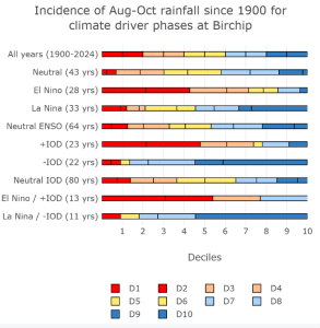
- There have been many more El Nino events than bad droughts. In the last 124 years there have been 28 El Nino events which is around 1 in 4 years. El Nino increases the chance of a drought but this is not a guarantee. The Local Climate Tool can be used to rank the rainfall in El Nino years at Birchip and while there are some very dry springs, there are plenty of reasonable ones.
- Most international models are predicting that the central Pacific Ocean will continue to warm to high levels. This has led to media discussion of super El Nino, Monster El Nino and even Godzilla El Nino, complete with pictures of drought, empty dams and starving stock. Climate scientists point out that the impact of El Nino in Australia is not closely related to the strength of El Nino.
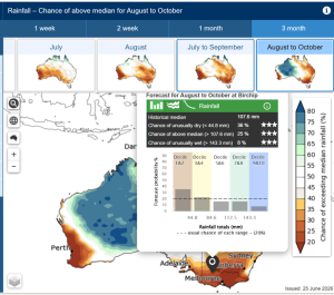
- The Bureau of Meteorology encourages use of their seasonal forecast which incorporate many climate influences rather than just focussing on El Nino. The forecast is updated every 2 weeks on a Thursday. It is easy to misinterpret the brown colour on the maps as a forecast of no rain rather than a change in probabilities (as shown in the map legend).
- Clicking on the magnifying glass
 enables the user to enter a location and get the forecast spread across deciles for a single location. If there was no signal in the forecast there would be around 20 of the computer runs in each of the five bins. This shows that more of the runs have ended up dry at Birchip and the chance of a very wet finish (decile 9 and 10) has reduced from 20% to 8%. However the chance of decile 7&8 has only reduced from 20% to 16%. All of the 100 runs of the computer are valid and equally possible.
In November 2026 we will know what happened. This will be used to judge the forecasts and decisions made in June. If the season turns dry the forecasts will be grudgingly accepted as correct for once, if we land on the 25% of runs that are wet, there might be articles blaming the Bureau for scaring growers off what anyone could see was going to be a good season. Forecasts and decisions made in June are more usefully judged on whether they used the best information available in June.
____________________________________________________________________________________________________________________________________
Peter Hayman leads SARDI Climate Applications which links the advances in climate science to primary industries in southern Australia. He is on the national team of the GRDC RiskWi$e project and works closely with climate science from the Bureau of Meteorology and CSRIO.